Three waterfalls in the Valmalenco


Three waterfalls in the Valmalenco
VALMALENCO
June 19, 2026 - June 26, 2026
Quite Possibly the Last Secluded Trails in Italy
Valmalenco may be the last undiscovered corner of the Italian Alps for hikers who enjoy the solitude of the trail. The region, tucked beneath the Swiss border, is still steeped in Italian traditions and the culture of mountaineering, this is an area you want to experience before the crowds get there.
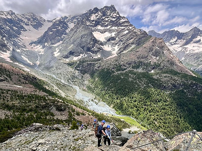
The Valmalenco in Italy's Valtellina, located in the heart of the Rhaetian Alps, is an almost unknown paradise for hikers. The glaciers of the Disgrazia, the Bernina and the Scalino amaze and impress, the water of the alpine lakes shimmers crystal clear, and on the high-altitude alpine pastures covered in wildflowers the concerns of daily life seem far away. The variety of the terrain is also thrilling. Walk under a waterfall, cross vast meadows, do some rock scrambling, and scale a Via Ferrata if weather allows.
Our accommodations are in mountain Rifugios operated by the same families for generations. In the evenings homemade pasta graces the dinner table and the local wines pair deliciously with the authentic regional Italian cuisine. This area of Italy is not to be missed for it is one of the last places undiscovered by tourists living outside of the Italian Alps. American accents are still a rarity.
During the week we hike with a daypack and spend the night in two Rifugios managed by local families. The hospitality of the people of the Lombardy region is epic. You will enjoy meeting the innkeepers and listening to stories of the mountains and folklore of the region as you enjoy a glass of local wine.
Explore this secluded and inspiring mountain world! Hike for a week, pack your backpack for just a day!
Day 1
Milan to Sondrio to Chalet Tana del Grillo.
We willl meet at the Milano Centrale train station for the trip to Sondrio where our shuttle will meet us for the drive to our first rifugio. After checking into the rooms, we hike to the Rifugio Tartaglione Crispo (elev. 1,750m) where we savor our first cappuccino and look forward to our week of hiking. After enjoying our break on the mountain, we begin the trip back to Chiareggio.
Arrival approx. 18.00 hrs.
Walking time approx. 2.5 hours, 200 meters ascent, 200 meters descent
Trail category: BBBBBB
Accommodation: Hotel Chalet Tana del Grillo
(B=Easy, R=Moderate, S=Difficult)

Day 2
Tana del Grillo to Rifugio del Grande Camerini.
Today's hike starts from the Tana del Grillo Inn and climbs over the Alpe Vezzeda to the fantastically situated Rifugio del Grande Camerini. The Rifugio is located at an altitude of 2,580m on the watershed between Val Sissone and Val Bona above Chiareggio (hamlet of Chiesa in Valmalenco-SW) and offers the best view of the spectacular north face of Monte Disgrazia and its glacier.
Its elevated position allows a sweeping 360 degree view of the surrounding high border mountains. On the terrace of the Rifugio, in good weather, with good friends, and sipping a good glass of local wine, the view is unforgettable and deeply moving.
Afterwards we hike back to Chiareggio (1,612 m) and in the evening we are spoiled by traditional local homemade dishes and local wine. Walking time approx. 5.5 hours, ascent 950 meters in altitude, descent 950 meters in altitude, length approx. 9.5 km
Trail category: BRRRBB
Accommodation: Hotel Chalet Tana del Grillo

Day 3
Chiareggio to Alp Fora to Rifugio Longoni (elev 2,450 m) to Chiareggio
From Chiareggio (1,612 m) we walk on the "Alta Via Valmalenco". Once past the Alpe Fora (2,055 m ) the terrain becomes more challenging and more alpine. The trail continues to Rifugio Longoni, located at 2,450 m. This hut is the starting point for the high alpine tours to the Sassa di Fora, Pizzo Tremogge and Pizzo Malenco. While enjoying the beautiful view, we refuel with spaghetti or a homemade minestrone. After the break, we continue to Alpe Entova, at the idyllically situated lake of the same name (1,863 m). Through shady forests and blooming alpine meadows, the trail leads back down to our starting point in Chiareggio.
Walking time approx. 6 hours, ascent 1000 m, descent 1000 m
Trail Category: BBRRBB
Accommodation: Hotel Chalet Tana del Grillo

Day 4
Lago Pirola to Torrione Porro (2,435 m)
This exciting stage takes us to Lago Pirola (2,280 m), which is nestled in an impressive mountain landscape. Today we have the chance to do some Via Ferrata routes if conditions permit. A few short sections of the trail are secured with ropes and the boulder strewn alpine terrain requires some skill. On a short detour we climb the summit of Torrione Porro (2,435 m) where the view of Monte Disgrazia, originally called Pizzo Bello, is magnificent. The vivid colors of the mountain are due to the serpentine that is common in the Valmalenco mountains. The descent from the pass (2,350 m) is somewhat exposed and interspersed with boulders. Arriving in Valle Ventina, we pass by two typical Lombard huts. It is difficult for us to decide which one we are going to go to. After a long rest, we hike back to Chiareggio and transfer to our new accommodations for the remainder of the trek.
Walking time approx. 5.5 hours, ascent 800 m, descent 800 m, length approx. 11 km Trail category: BRRSRB
Accommodation: Hotel Rifugio Zoia

Day 5
Val Poschiavina to Passo Campagneda (2,628 m)
Today's hike is a classic route, the trail to Val Poschiavina. The path in the morning is not technically difficult and leads to the Poschiavina Alp (2,250 m). After the initial stage we follow the stream of the same name until reaching Passo Cancian (2,464 m). From there, it's just an hour to the highest point of the trail, the Passo Campagneda at 2,628 m. The view of the icy summit of the Bernina Group, the Piz Argient, the Piz Zupó and the Pizzo Scalino are overwhelming. Passing beautiful mountain lakes, we climb over a challenging terrain filled with boulders and head downhill to Alp Campagneda (2,147 m). The last easy ascent back to Rifugio Zoia ends the day.
Accommodation: Rifugio Zoia
Walking time approx. 6 hours, ascent 650 meters in altitude, descent 650 meters in altitude, length approx. 14 km. Trail category: BBBRRB

Day 6
Monte delle Forbici (2,910 m)
After breakfast, we set off on the summit tour to Monte delle Forbici (2,910 m). After approximately 2.5 hours of walking we reach the Carate Hut (2,640 m). After a short breather, the alpine ascent to the summit begins. A 360° panoramic view is the reward for the effort. The descent is on the same route. End the day relaxing In the sauna of the Rifugio Zoia (2,021 m).
Accommodation: Rifugio Zoia
Walking time approx. 6.5 hours, ascent 1000 meters in altitude, descent 1000 meters in altitude, length approx. 13 km
Trail category: BBRRBB

Day 7
Rifugio Bignami (2401 m) Glacier Trail.
Today we cross the reservoir wall from Lago di Gera to the Rifugio Bignami. We then continue to the edge of the glacier of the Fedretta di Fellaria Orientale. From here we have a unique view of the glacier escarpments and the imposing area of Valmalenco. Accommodation: Rifugio Zoia
Walking time approx. 7 hours, ascent 850 meters in altitude, descent 850 meters in altitude, length approx. 15.5 km.
Trail category: BBRRBB

Day 8
Rifugio Christina (2,226 m)
Today is pure enjoyment. The hike to Rifugio Christina (2,226 m) highlights the unique characteristics of the landscape on the Piano di Campagneda. The Rifugio Cristina was built in 1924 by Bricalli Ersilio and is now managed by his great-granddaughter Vania. After lingering until our hearts content at the Rifugio we hike back to the starting point. In the afternoon it's time to say goodbye to Emanuele, the host of the Rifugio Zoia, and start the journey back to reality.
Walking time approx. 4.5 hours, ascent 350 meters in altitude, descent 350 meters in altitude, length approx. 10 km
Trail category: BBBBBB